


Mumbai Rain Alert: 150+ mm Rainfall Expected in 36 Hours, IMD Issues Orange Warning for July 23-24
IMD issues Orange Alert for Mumbai as over 150 mm rain expected in next 36 hours. Heavy rain likely on July 23-24. Flooding and traffic disruptions anticipated
Mumbai Rain: The financial capital is in for another wet spell as the India Meteorological Department (IMD) has issued a heavy rainfall alert for July 23, warning of intense downpours that could cross 150 mm over the next 24 to 36 hours. An orange alert has also been sounded for Wednesday, 24 July, as the monsoon continues to flex its strength along the Konkan coast.
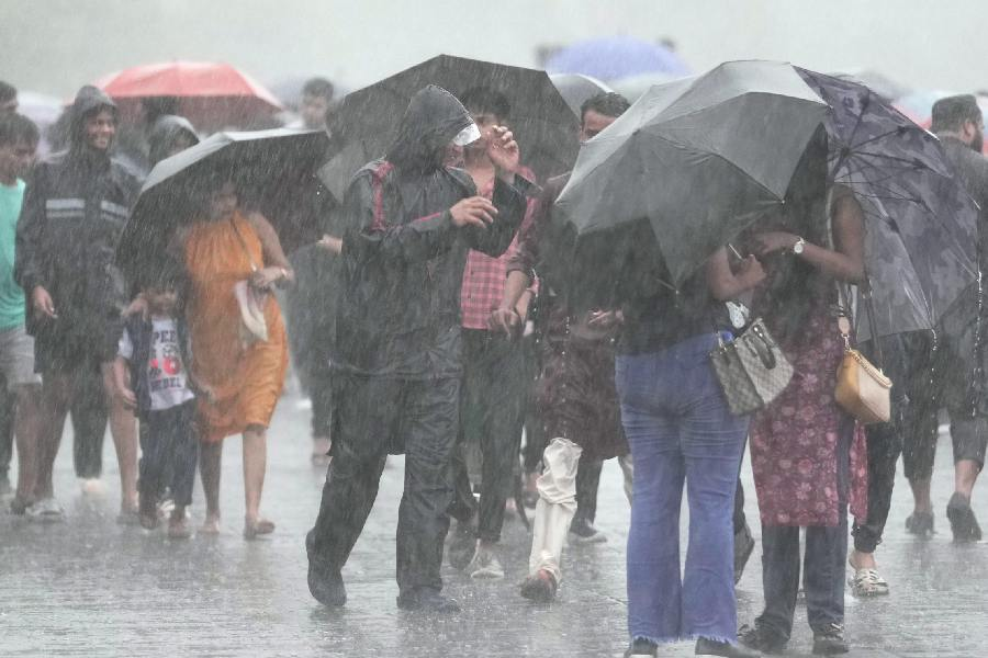
The advisory comes with a clear message: plan your day accordingly and stay safe, especially if you’re in flood-prone or low-lying areas.
The IMD’s orange alert signifies that heavy to very heavy rainfall is likely in isolated parts of Mumbai and adjoining districts like Thane and Palghar. Authorities have been put on alert, with the BMC ramping up preparations to manage potential waterlogging and traffic snarls.
With saturated ground conditions from recent rains, even a few hours of steady showers could trigger waterlogging, particularly in:
- Sion
- King’s Circle
- Hindmata
- Kurla
- Andheri Subway
- Dahisar and Malad underpasses
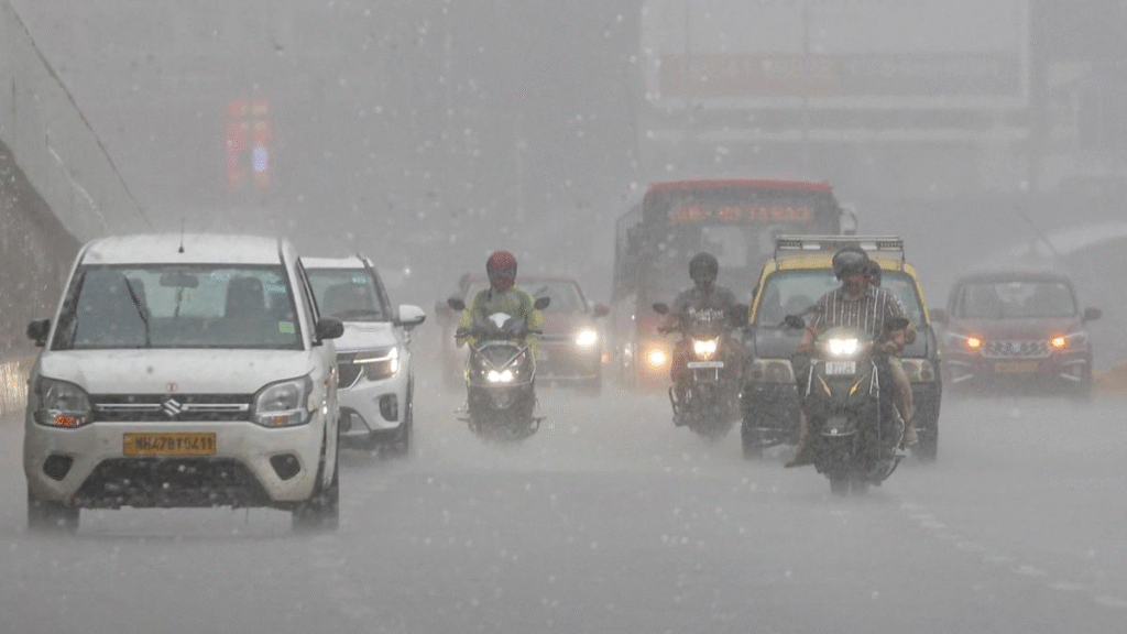
Rainfall intensity is expected to rise from late morning into the afternoon and continue overnight. Isolated intense spells could cause disruption in rail and road traffic, so commuters are advised to leave early, carry umbrellas or rain gear, and avoid venturing out unnecessarily during peak rainfall hours.
Temperatures are expected to hover around 29–30 degrees Celsius , with high humidity levels adding to the discomfort.
City authorities have urged residents to follow official updates, keep emergency contacts handy, and avoid venturing near seafronts, creeks or manholes. Fisherfolk have also been advised to stay ashore.
With schools and offices slowly returning to full attendance post monsoon break days, Mumbaikars are reminded to plan ahead, allow for delays, and prioritise safety. The rain gods aren’t done with Mumbai yet.
Mumbai is bracing for intense rainfall as the India Meteorological Department (IMD) has forecast over 150 mm of rain in the next 36 hours, issuing an Orange Alert for July 23 and 24. The warning comes after continuous downpours have already disrupted daily life across several parts of the city.
The IMD has cautioned citizens about possible localized flooding, waterlogging, and traffic snarls, especially during peak hours. Low-lying areas including Sion, Dadar, Kurla, and Andheri may experience severe water accumulation.
According to the forecast, heavy to very heavy rainfall (64.5 mm to 204.4 mm) is expected over Mumbai, Thane, and adjoining districts. In some pockets, isolated extremely heavy rainfall (above 204.5 mm) cannot be ruled out.
Disaster management teams have been placed on high alert, and Mumbai civic authorities (BMC) have activated control rooms and issued advisory messages to residents urging caution, especially in flood-prone zones. Local trains and BEST bus services may be affected due to waterlogged tracks and roads.
In the past 24 hours, Mumbai has already recorded over 95 mm of rainfall in parts of the suburbs, leading to delayed train schedules and traffic congestion.
The Orange Alert signals preparedness for potential hazards and is one level below the Red Alert, which indicates extremely severe conditions. Authorities are advising Mumbaikars to avoid unnecessary travel, keep emergency kits ready, and stay tuned to official updates.
According to the IMD’s latest bulletin, the coastal city will experience heavy to very heavy rainfall, with some isolated pockets possibly recording extremely heavy rainfall exceeding 200 mm. This development comes as part of a renewed surge in the southwest monsoon, which has already battered parts of Maharashtra over the past week.
Rainfall ranging from 64.5 mm to 204.4 mm is classified under “very heavy”, while anything above 204.5 mm falls under the “extremely heavy” category. The IMD alert suggests that the eastern suburbs and low-lying areas of Mumbai are likely to witness intense spells, potentially leading to flooding, waterlogging, traffic disruptions, and power outages.
Regions such as Kurla, Sion, Dadar, Chembur, Andheri, Malad, Borivali, and parts of Navi Mumbai have been identified as potential hotspots for waterlogging. These zones, already prone to drainage issues, may face severe disruptions during peak traffic hours if the rain continues unabated.
In the last 24 hours, Mumbai recorded between 80 to 95 mm of rainfall, with the Santacruz observatory noting a significant spike. If the forecast holds, the city could witness another round of traffic snarls, suburban train delays, and even flight disruptions.
The Brihanmumbai Municipal Corporation (BMC) has stepped up its preparedness, deploying additional pumping equipment, activating 24×7 control rooms, and dispatching emergency response teams to vulnerable locations. Schools and colleges are still expected to operate on regular schedules, though authorities have asked parents and institutions to stay alert to updates.
The Mumbai Police has also issued advisories urging citizens to avoid venturing into sea-facing areas like Marine Drive, Worli Sea Face, and Juhu Beach during high tide. According to tidal data, high tide timings coincide with heavy rain forecasts, increasing the risk of backflow flooding.
The Mumbai Local Train Network, the city’s lifeline, may see delays and temporary halts in service, particularly on the Central and Western lines, if water levels rise on tracks. Commuters have been advised to check real-time updates via mobile apps and radio stations before stepping out.
BEST bus routes may also be diverted in case of submerged roads. Emergency numbers for weather updates, disaster response, and road block alerts have been circulated across social media platforms and public transport systems.
Read Also : 23-Year-Old Indian Student Brutally Beaten in Adelaide: Suffers Severe Brain Trauma After Shocking Assault

