Cyclone Montha Intensifies: Category 4 Storm to Hit Andhra Coast This Evening
Cyclone Montha has intensified into a severe cyclonic storm and is set to make landfall along the Andhra Pradesh coast this evening
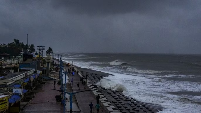
Cyclone Montha’s impact is being felt along the Uppada coast, where the sea has turned turbulent and powerful waves are battering the leaving it completely damaged. Eluru Range DIG Ashok Kumar visited the coastal area and urged residents to stay alert, saying the cyclone may cross the coast either around midnight or tomorrow morning.
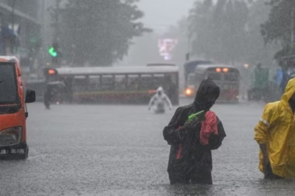
As moves closer to the Andhra coast, Chennai witnessed heavy rain on Tuesday morning, leading to waterlogging in areas like Choolaimedu. The Regional Meteorological Centre (RMC) has issued a warning for moderate rain with light thunderstorm and lightning till 1 pm today.

According to the IMD, districts including Chengalpattu, Chennai, Kanchipuram, Ranipet and Thiruvallur are likely to receive more rain, while isolated showers are expected in Kanyakumari, Tenkasi, Tirunelveli, Tiruvannamalai, Vellore and Viluppuram.
Officials have warned of waterlogging, slippery roads, and traffic disruptions in some areas due to the impact of Cyclone Montha’s outer bands triggering rainfall over north Tamil Nadu.
According to the India Meteorological Department-IMD, Cyclone Montha formed over the southeast Bay of Bengal as a low‐pressure system and quickly evolved into a cyclonic storm.
By early Tuesday 28 October 2025 it had further intensified into a “severe cyclonic storm”.
Its core was located approximately 190 km south-southeast of Machilipatnam, 270 km south-southeast of Kakinada and 340 km south-southeast of Visakhapatnam, at 5:30 AM local time.
It is moving north–northwestwards at roughly 15 km/h and is being guided by steering winds in the Bay of Bengal.
The IMD projects that Montha will make landfall between Machilipatnam and Kalingapatnam (around the region of Kakinada) on the coast of Andhra Pradesh this evening or night of 28 October 2025.
At landfall, the storm is expected to carry sustained winds of 90–100 km/h, with gusts up to 110 km/h.
Additionally, a storm surge of about 1 metre above astronomical tide is forecast around landfall time, which may inundate low-lying coastal zones.
Coastal and adjoining districts of Andhra Pradesh are on high alert. According to reports:
Red alerts (highest level) have been issued for many coastal districts including Prakasam, Bapatla, Krishna, West Godavari, Dr. B.R. Ambedkar Konaseema, Kakinada and Nellore.

In total, 23 of the 26 districts in Andhra are under some form of alert for heavy rainfall and strong winds.
Over 3,778 villages in the state are on rain alert, per recent reporting.
The neighbouring state of Odisha is also preparing for secondary effects despite landfall being in Andhra Pradesh.
Heavy to extremely heavy rainfall: Many coastal and inland areas will see very intense rain which may cause flooding, waterlogging and landslides.
Strong winds and gusts: Sustained winds of up to 100 km/h and gusts up to 110 km/h will affect buildings, power lines, trees and weaker structures.
Storm surge and high sea waves: Coastal inundation possible, especially in low-lying areas, with sea conditions being very rough.
Disruption to transport, power & communication: Already train services, flights, and bus operations are being affected.
Potential for flooding inland: Rain‐bands will extend inland beyond the coastal belt — meaning districts not directly on the coastline must still prepare.
The Andhra Pradesh government has opened relief-/cyclone shelters, readied evacuation procedures in vulnerable zones, and imposed restrictions in certain sectors.
Several teams from the National Disaster Response Force (NDRF) and State Disaster Response Forces (SDRF) are on standby.

Transport services: The Andhra Pradesh State Road Transport Corporation (APSRTC) has suspended night‐halt bus services in cyclone-affected areas, activated 24×7 communication cells and moved buses from low-lying depots to higher grounds.
Aviation and rail: Over 65 trains were cancelled across coastal Andhra, flights from Visakhapatnam were suspended or disrupted.
Central government support: The Prime Minister assured full central assistance to the state.
Heed official alerts and evacuations: If your local administration asks you to evacuate, leave immediately for designated shelters.
Stay indoors during the peak of the storm: Avoid going out when the wind and rain intensify.
Secure your home: Close windows, secure loose items outside, reinforce shutters or doors if possible.
Avoid low-lying and flood-prone areas: Stay away from riverbanks, sea-coast, and vulnerable zones.
Do not venture into the sea or floodwaters: Even shallow floodwaters can hide hazards or be moving dangerously fast due to storm surge.
Prepare emergency supplies: Torch/flashlight, batteries, first‐aid kit, drinking water, important documents, mobile phone charger, basic medicines.
After the storm: Be cautious of fallen power lines, disrupted roads, weakened structures and large debris.
Landfall expected evening/night of 28 October 2025 between Machilipatnam and Kalingapatnam.
Storm category: Severe Cyclonic Storm with sustained winds ≈ 90-100 km/h, gusts up to ~110 km/h.
Storm surge: ~1 metre above tide expected.
Number of villages in Andhra on rainfall alert: ~3,778.
Number of districts in Andhra under alert: 23 of 26.
The east coast of India is habitually vulnerable to tropical cyclones forming in the Bay of Bengal due to warm seas and conducive meteorological conditions.
Such events not only bring immediate destructive impacts (winds, rain, surge) but also trigger lingering damage — to homes, agriculture, infrastructure, power supply and everyday livelihoods.
In this case, the rapid intensification of Montha and the broad area of impact mean that emergency response and preparedness are critical to minimising loss of life and damage. The latest reports emphasise that the state aims for a “zero casualty” target.
Relief & rescue operations: Reaching stranded populations, restoring communications and utilities, delivering food, medicine and shelter.
Damage assessment: To roads, bridges, power grid, telecom, agriculture (especially coastal crops) and housing.
Health & hygiene: Post-flood conditions can trigger health risks (waterborne diseases, vector issues).
Reconstruction efforts: With early mobilisation of funds and manpower. The state has already sanctioned advance funds to affected districts.


